(you are in: overfishing.org / articles / satellite images from bottom trawling)
Bottom trawling -also known as Benthic trawling- is a fishing method that involves dragging trawl nets along the sea floor. The fishing method is a highly non-selective one and comes with a large amount of bycatch and destruction in the trawled path. Bottom trawling activities are performed world wide in coastal and deep waters.
Modern satellite imagery clearly show the mud trails, distortion and other destruction left by the coastal -shallow water- version of these trawling activities. The online mapping service Google Earth is used to illustrate a number of these from across the world. Hover over the buttons on the right to quickly switch between these areas. The tool-tips from the red pointers provide some more information. Use the zoom buttons to browse around an area and discover the scope of destruction.
Satellite images are Quickbird, Landsat and aerial photographs, and loaded via the Google Maps server. Trawling imagery was available at the time of writing. Note: as of mid-2010 Google has updated its mapping website, causing this application to stop working. While the interactive map has stopped working the images below are still available.
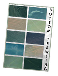
By popular demand (three is a crowd) a fancy poster has been created showing ten examples -from eight countries*- of bottom trawling. The poster comes in two different sizes, is colourful, educational and looks pretty good on just about every wall. See the thumbnail on the right for a preview.
A4, 1818x2572 pixels, 1.774kb -> DOWNLOAD! (jpg)
A3, 2572x3638 pixels, 3.130kb -> DOWNLOAD! (jpg)
A3 / A4, Adobe PDF file, 2.833kb -> DOWNLOAD! (pdf)
The satellite imagery used is public domain or free to distribute. Feel free to use this poster as you like. It is much appreciated if you leave the original links and text intact.
* trawling imagery from Ecuador, USA (Georgia and Louisiana), Netherlands (Vlieland and Westerschelde), Phillipines, China, Malaysia, Indonesia and Mexico.
Along the coasts of The Netherlands, Germany and Denmark there lays a shallow coastal sea -with associated wetlands and islands- extremely rich with all types of important sea (it serves as a spawning and nursing grounds for fish) and bird (millions of migratory birds use the mud flats to feed on) life. Large parts of the sea consist of tidal mudflats. The intertidal area is sea during high-tide and dryish land during low-tide.
For decades there have been bottom trawling and dredging activities on the Dutch part of the area. As of July 1, 2004 mechanical cockle fisheries have been banned in order to preserve the cockles (and the rich bottom) for the millions of birds. However, some fisheries on mussels (mariculture) and shrimp are still taking place.
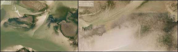
Here are two low-tide imageres showing the marks / scarves left by various trawling activities. These take years to disappear from visual sight and even longer for the benthic situation to return to the pre-trawling situation.
The images are composites from aerial photographs, the location is near the island of Texel.
trawl location one, 1930x1276 pixels, 1.327kb -> DOWNLOAD! (jpg)
trawl location two, 1728x891 pixels, 895kb -> DOWNLOAD! (jpg)